
Minnesota regulators said Northshore Mining's planned 650-acre tailings basin expansion doesn't require an environmental review and awarded the project a key water permit this week.
In a 68-page environmental review of need determination, the Minnesota Department of Natural Resources on Monday said because the project was within the maximum size considered in the 1975-1976 environmental impact statement, or EIS, it prepared with the Minnesota Pollution Control Agency, a new environmental assessment worksheet and supplement to its EIS were not needed.
ADVERTISEMENT
The determination cleared the way for the MPCA on Tuesday to grant the project a 401 certification, a permit awarded by a state's regulators if the project's impact on water falls within the state's standards. The agency said the project would “directly impact” 264 acres of wetlands.
The U.S. Army Corps of Engineers must now weigh whether the project's construction-related impacts to U.S. waters comply with federal laws. If it does, it can grant a permit allowing the company to discharge dredged and fill material into rivers and streams.
Northshore owner Cleveland-Cliffs is planning to expand the footprint of its 2,150-acre Milepost 7 tailings basin near Silver Bay by 650 acres — a 30% increase in the basin's surface area. The famed basin was completed in 1980 after then-owner Reserve Mining was forced to stop its decades-long practice of dumping tailings — the fine pieces of waste rock left over after taconite is crushed and stripped of iron ore — directly into Lake Superior and years of court battles over the tailings' pollution and asbestos-like fibers found in the drinking water of Duluth.
To expand, Cliffs is planning to move a railroad embankment currently on the northwesternmost edge of the basin another 4,000 feet to the northwest. The railroad embankment would then serve as that side's dam and boundary while existing, natural elevation gains serve as basin barriers. The height of the dams — currently between 1,241 and 1,255 feet would also rise to 1,315 feet above sea level — the maximum height it’s permitted for — while tailings would be stored 10 feet below the top of the dams at 1,305 feet “to prevent overtopping in the event of extreme precipitation events,” the determination said.
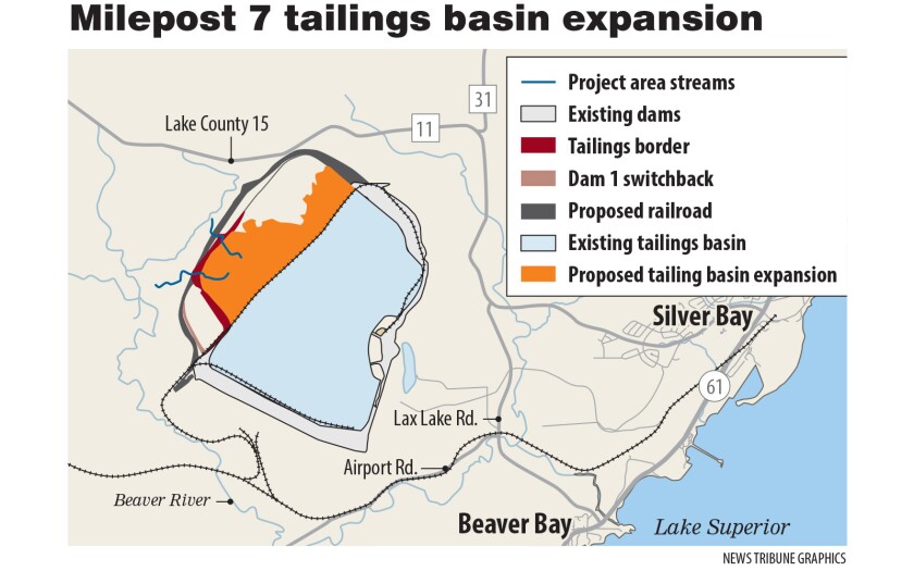
Although a state administrative rule requires an environmental assessment worksheet be prepared if a tailings basin is expanded by 320 or more acres, the DNR said that one would not be necessary because the basin’s original EIS prepared by the DNR and MPCA in 1975 and 1976 planned for up to a 2,950-acre basin — 150 acres larger than the size planned in this expansion — and a maximum height of 1,315 feet.
ADVERTISEMENT
But Paula Maccabee, counsel and advocacy director of environmental group WaterLegacy, said the old environmental reviews, nearing a half-century old, are outdated and alternative ways to store tailings should be considered.
“The idea that they’re relying on a chicken scratching from 1975, rather than doing environmental review under modern standards, is so shocking to me,” Maccabee said.
She added that the agencies should have considered the more stringent 1977 federal EIS instead of the 1975-76 state EIS.
In an email to the News Tribune, DNR Assistant Commissioner Jess Richards said the agency’s responsibility was to determine whether it needed to prepare a supplement to the state EIS for the project and that the federal EIS was outside of its authority.
“The DNR’s authority is under the Minnesota Environmental Protection Act and therefore our role was to determine whether the state EIS needed to be supplemented,” Richards said. “The (U.S. Army Corps of Engineers) EIS would have been prepared under the National Environmental Policy Act.”
Both reviews originally expected the dams to be built using the downstream construction method, which is considered safer than upstream dams. But in 1997, the DNR and MPCA approved Cliffs to use the upstream method. By 2003, however, work on dams shifted to “modified centerline (or offset upstream) method of construction,” which combines the centerline and upstream methods.
That will continue in this expansion.
ADVERTISEMENT
“More relevant, the current Permit Amendment with the proposed dam extensions will continue to use the modified centerline construction method,” the DNR’s determination said. “Thus the new information regarding whether the upstream dam construction method is safe is simply not an issue at Mile Post 7.”
Cliffs did not respond to the News Tribune’s request for comment.